Site Analysis Checklist for Architects: 40 Things to Check
A site analysis checklist lists everything an architect should find out about a site before designing: context, built form, history, uses, access, climate, sun, ground, services and rules. This one has 40 checks, split into what you can do at your desk and what you can only see on site, with the source for each.
Use it before the first sketch, tick it on the site visit, and keep the answers with the project. Every check has a reason: if an answer would not change the design, skip it on that project.
Last checked: October 2026. Free to copy and print; no email needed.
How should you use a site analysis checklist?
- Desk study first. Do checks 1 to 28 from data before you visit. Print the maps.
- Site visit second. Do checks 29 to 40 on site, with the maps in hand.
- Write the answer, not a tick. "Prevailing wind from the south-west, 19% of hours" is useful later; a tick is not.
- End with design moves. Turn the answers into a short list of moves, as in the complete site analysis guide.
Desk study: what can you check before visiting?
Location and context
| # | Check | Why it matters | Where to find it |
|---|---|---|---|
| 1 | Site boundary and area | Everything else is measured from it | Title plan, survey, or draw it on a map |
| 2 | Neighbourhood character | Sets the scale and language of the design | Figure-ground, street photos |
| 3 | Figure-ground within 250 to 500 m | Shows grain, density and open space | Figure-ground map maker |
| 4 | Building heights around the site | Sets the height a scheme is judged against | Building height map, survey |
| 5 | Street section across the site | Shows enclosure and sky | Site section maker |
| 6 | Landmarks and views | Views to protect, frame or block | Maps, heritage register |
History and heritage
| # | Check | Why it matters | Where to find it |
|---|---|---|---|
| 7 | Building ages around the site | The fabric you are adding to | Building age map |
| 8 | Listed buildings and protected areas | Can stop or shape a scheme | National and city heritage registers |
| 9 | Past uses of the site | Contamination, foundations, archaeology | Historic maps, archives |
| 10 | Archaeology zones | Can add months to a programme | City archaeology maps |
Uses and access
| # | Check | Why it matters | Where to find it |
|---|---|---|---|
| 11 | Land use around the site | What the area needs and tolerates | Land use map |
| 12 | Shops, schools, health within 400 to 800 m | Sets the programme and parking need | Amenity map, OpenStreetMap |
| 13 | Public transport stops and frequency | Parking ratio, entrances, density | Transit map, operator timetables |
| 14 | Street hierarchy | Where the main entrance and servicing go | Street hierarchy map |
| 15 | Walking and cycling routes | Entrances, bike storage | Accessibility map |
| 16 | Vehicle and service access | Deliveries, refuse, fire access | Street plans, local rules |
| 17 | Traffic noise sources | Room layout, glazing, ventilation | Noise maps |
Climate, sun and ground
| # | Check | Why it matters | Where to find it |
|---|---|---|---|
| 18 | Temperature range and extremes | Heating, cooling, shading | Climate archive, weather files |
| 19 | Rainfall and wet days | Roofs, drainage, covered space | Climate archive |
| 20 | Prevailing wind by season | Entrances, balconies, natural ventilation | Wind rose |
| 21 | Sun path at solstices and equinox | Orientation, daylight, solar gain | Sun path diagram |
| 22 | Overshadowing from neighbours | Daylight to homes and gardens | Shadow study, shadow calculator |
| 23 | Ground levels and slope | Access, drainage, cut and fill | Contours, survey |
| 24 | Flood risk and water | Floor levels, basements, insurance | Flood maps |
| 25 | Trees and green cover | Protected trees, shade, ecology | Tree surveys, land cover data |
Rules and services
| # | Check | Why it matters | Where to find it |
|---|---|---|---|
| 26 | Zoning and allowed uses | Whether the brief is possible at all | Local plan, zoning map |
| 27 | Height, coverage, FAR and setbacks | The buildable envelope | Local code, FAR calculator |
| 28 | Utilities and easements | Where you can and cannot build | Utility maps, title documents |
Site visit: what can you only see on site?
| # | Check | What to note |
|---|---|---|
| 29 | Arrival | How you naturally arrive, and the first view of the site |
| 30 | Edges | What each boundary is: wall, fence, building, open |
| 31 | Party walls and neighbours' windows | Rights of light, overlooking, structure |
| 32 | Condition of existing buildings | Keep, adapt or demolish |
| 33 | Noise at different times | Morning, school run, evening |
| 34 | Smells and nuisances | Kitchens, bins, workshops |
| 35 | Light on site | Where the sun actually falls, compared with the diagram |
| 36 | Wind on site | Corners and gaps where it gusts |
| 37 | How people use the street | Where they wait, cross, sit, park bikes |
| 38 | Views out | What the best rooms should look at |
| 39 | Ground and drainage | Wet patches, levels, kerbs |
| 40 | Photos, pinned to the plan | One per observation, located |
What does a finished checklist look like?
On a real site, a Keizersgracht block in Amsterdam, three of the answers read:
- #7 Building ages: 445 of 501 buildings within 250 m have a recorded date; the median is 1760; 87 are older than 1700.
- #12 Shops and services: within 400 m, 98 cafés and restaurants, 3 supermarkets, 3 schools or nurseries, 4 pharmacies or doctors.
- #20 Wind: from the south-west 19% of hours in 2025 and the south 19%; calm only 1.1% of hours.
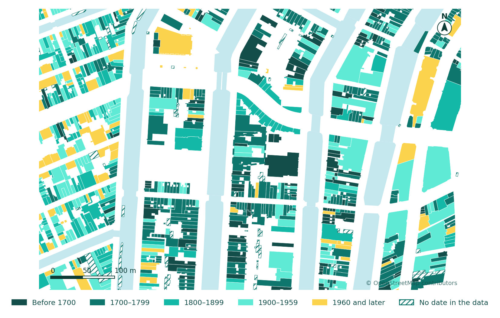
Each answer points to a decision: match the old roofline, skip the car park, shelter the south-west corner. That is the difference between a checklist and a site analysis.
What should you add to the checklist on an Indian site?
The 40 checks hold everywhere, but some answers carry far more weight in India. Add these to the desk study:
| Check | Why it matters in India | Where to find it |
|---|---|---|
| Protected monuments within 300 m | Under the AMASR Act, nothing new can be built within 100 m of a centrally protected monument, and the next 200 m needs National Monuments Authority permission | ASI circle lists, NMA, state archaeology department |
| Master plan and local building rules | Coverage, FAR, height and setbacks come from the master plan and bye-laws, such as Delhi's MPD and Unified Building Bye-Laws or Mumbai's DCPR 2034 | Development authority and municipal websites |
| Plot size category and road width | Rules change by plot-size band, and in many cities FAR rises with the width of the road the plot faces | The same rules, plus a measured road width |
| Stilt parking and height | Stilt parking is often excluded from FAR but counts in height, which decides how many floors fit | Bye-laws |
| Fire and airport height limits | Fire service clearance and an Airports Authority of India height NOC can cap height | Fire service rules, AAI's online NOC maps |
| Mandatory green measures | Rainwater harvesting, solar and waste segregation are required on many plot sizes | Bye-laws |
| Monsoon flooding and waterlogging | Most of the year's rain falls in a few months | Municipal drainage maps, local knowledge, the site visit |
| Building heights | Open data rarely records storeys, so heights come from the site visit | Site visit, photos |
On the Green Park block in New Delhi, three answers read:
- Heritage: Bara Khamba, Chhoti Gumti and Sakri Gumti, all centrally protected, stand about 190 m, 230 m and 280 m away, so the block is in their regulated area and needs NMA permission.
- Rules: a 300 m² plot falls in the band of more than 250 and up to 500 m²: 75% coverage, FAR 225, 15 m high or 17.5 m with stilt parking (MPD-2021 norms; MPD-2047 was notified on 20 August 2026, so check its regulations).
- Climate: 30 days at 40 °C or more in 2025 and 85% of the rain from June to September.
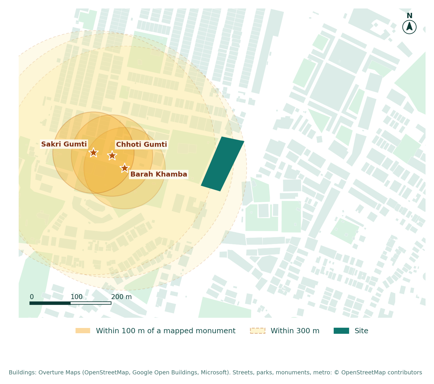
The full Delhi analysis is in the complete site analysis guide.
How can you fill in the desk study faster?
Checks 1 to 28 are mostly data. Pulling them by hand takes a day or more per site. UrbanEyes Site Analysis fills most of them for any address in about fifteen minutes, each with its source: context maps, building heights and ages where recorded, land use, amenities, transit, climate, sun and wind, and a feasibility screen for supported countries. You can keep the checklist on a site analysis board beside the maps.
Frequently Asked Questions
What should be included in a site analysis checklist?
Location and context, built form and heights, history and heritage, uses and amenities, access and transport, climate, sun and shadow, ground and water, trees, planning rules and utilities, plus site-visit checks such as edges, noise, light and views.
What is the difference between a desk study and a site visit?
The desk study collects what data and documents can tell you before visiting. The site visit checks what data cannot show: condition, noise, use, light on the ground and views.
How many items should a site analysis checklist have?
Thirty to fifty is typical. This one has 40: 28 for the desk study and 12 for the site visit. Drop items that would not change the design on your project.
Is there a free site analysis checklist?
Yes, this one is free to copy and print with no email. The tools linked in it, such as the figure-ground map maker, sun path diagram and FAR calculator, are free too.
What extra checks does a site analysis in India need?
Protected monuments within 300 m, the master plan and building bye-laws, the plot size band and road width, stilt parking and height limits, fire and airport height clearances, mandatory rainwater harvesting and solar, and monsoon flooding.
Can site analysis be automated?
The desk study largely can: maps, figures, climate and sun come from open data. The site visit, the judgement and the design moves cannot.

Chavisha Arora
Co-founder, UrbanEyes
Machine learning engineer, formerly at Tesla and Expedia. Chavisha leads the data and models behind UrbanEyes site analysis.
We analyse, you design.
Run data-backed site analysis with UrbanEyes: maps, metrics, and reports in about 15 minutes.